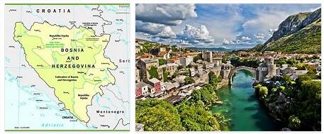
According to Andyeducation, Bosnia and Herzegovina is located in the western part of the Balkan Peninsula, bordered to the north, west and southwest by Croatia (932 km); to the east with Serbia (302 km) and to the southeast with Montenegro (225 km). The country is mostly mountainous, crossed by the Dinaric Alps. Sectors in the northeast intersect with the Pannonian plain, while in the south it borders the Adriatic Sea. But Bosnia and Herzegovina has only 20 kilometers of coastline, in the vicinity of the city of Neum -in the Herzegovina-Neretva canton-, which is located within the Croatian territory and its territorial waters, this small salient divides the Croatian coast into Two parts. Map of Bosnia and Herzegovina with its main cities.
The name of the country comes from two historical regions: Bosnia and Herzegovina, which currently have a vague border between them. Bosnia is located in the northern areas of the country that are approximately 4/5 of the territory and the rest, in the south, belong to Herzegovina.
The most important cities are: The capital Sarajevo, which is also Bosnian, Banja Luka in the northwest region known as Bosanska Krajina, Bijeljina and Tuzla in the northeast, Zenica in the central part of Bosnia and Mostar, which is the capital of Herzegovina.
The southern part of Bosnia has a Mediterranean climate and is ideal for agriculture, the central part is the most mountainous. The highest heights are the Vlasic, Cvrsnica and Prenj mountains. To the east it also presents mountains such as Trebevic, Jahorina, Igman, Bjelasnica and Treskavica.
The east is occupied by dense forests along the Drina river basin; almost 50% of the area of Bosnia and Herzegovina is forested.
The northwest area of Bosnia and Herzegovina is called Bosanska Krajina and in it are the cities of Banja Luka, Sanski Most, Cazin, Velika Kladisa and Bihać. Kozara National Park is located in this forested region.
The Una River runs along Bosnia’s northern and western border with Croatia, through the Bosnian city of Bihać. It is very popular for water sports and rafting.
The Sana River flows from the city of Sanski Most and is a tributary of the Sava River in the north.
The Vrbas passes through the central part of Bosnia, through the cities of Gornji Vakuf – Uskoplje, Bugojno, Jajce and Banja Luka and meets the Sava River in the north.
The Bosna is one of the longest. It rises near Sarajevo and flows north into the Sava.
The Drina flows from the eastern part of Bosnia and Herzegovina. In many places it forms the border between Bosnia and Herzegovina and Serbia. The Drina river passes through the cities of Foča, Goražde and Višegrad.
The Neretva River is found in the central and southern part of the country, running from Jablanica south to the Adriatic Sea. The city of Mostar lies on its shores.
The Sava River runs through the territories of Serbia, Bosnia and Herzegovina and Croatia. The Sava serves as a natural border between Bosnia and Herzegovina and Croatia and cities such as Brcko, Bosanski Samac, Bosanska Gradiska lie on the banks of this river.
Economy
It is currently one of the poorest republics in the former Yugoslavia due to the devastating war in Bosnia (1992-1995). During the war years, the economy was not only stagnant but experienced a huge setback, with most of the population subsisting on foreign humanitarian aid. The deterioration of the economy was joined by the economic blockade by neighboring countries – Serbia and Croatia.
The Bosnian convertible mark (konvertibilna marka, BAM) is the currency unit of this republic. It is divided into 100 pfennig (pfeninga). It has a parity against the euro of 0.51129 EUR per 1 BAM (that is, 1 EUR = 1.95583 BAM), the same that was set for the exchange of the old German mark with the appearance of the euro. There are currently in circulation (June 2006) coins of 5, 10, 20 and 50 pfennig, and of 1, 2 and 5 marks; as well as bills of 1, 2, 5, 10, 20, 50, 100 and 200 marks. Except for the 200 mark note, the others have two models: one for the Federation of Bosnia and Herzegovina, another for the Republika Srpska. This paragraph has been drawn up after consultation with the Central Bank of Bosnia and Herzegovina
In 1991, a year before the war, in the midst of the half-disintegrating former Yugoslavia economic crisis (Slovenia and Croatia were already outside the union), the gross domestic product was 14,000 million dollars, but the rate has decreased by a 37 percent since then.
Demography
Large population migrations during the Yugoslav Wars in the 1990s have caused a great demographic change. No census has been done since 1991 and it is not planned in the near future due to political disagreements. Since censuses are the only statistical means and even objective of analyzing demographics, almost all post-war data are simply an estimate. Most sources, however, estimate the population at nearly 4 million (representing a decrease of 350,000 people since 1991).
According to the 1991 census, Bosnia and Herzegovina had a population of 4,354,911. 43.7% Bosnian, 31.3% Bosnian Serb and 17.3% Bosnian Croat, with 5.5% declaring themselves Yugoslavs (in the former Yugoslavia the population declared as Yugoslavs was just 1%).
There is a strong correlation between ethnic identity and religion: 88% of Bosnian Croats are Roman Catholic, 90% of Bosnians are Muslim, and 93% of Bosnian Serbs are Orthodox Christians.
According to the year 2000 information from CIA World Factbook data, Bosnia and Herzegovina is ethnically 48% Bosnian, 37.1% Serbian, 14.3% Croatian and 0.6% other (Macedonians, Gypsies).